Cát Bà may be the best destination in northern Vietnam for exploring the unique seascapes of Ha Long Bay, a UNESCO-acclaimed world heritage site.
There’s something at once mystical and magical about a karst landscape — even moreso when it becomes a seascape.
Karst, for the uninitiated, is a natural topographical feature formed when water-soluble rocks like limestone (calcium carbonate) are dissolved by rain or flowing water. Beneath the surface, subterranean streams may create a labyrinth of caves and sinkholes, as erosion fails to penetrate more weather-resistant core rocks, such as quartzite.
Fantastic landscapes are often the result. The region around Guilin, China, is renowned for its narrow, steeply rising crags, often capped by remote temples, as depicted in centuries-old scroll paintings. The cenote of Mexico’s Yucatán Peninsula, an element of Mayan myth, were created by these same natural forces.

In northeastern Vietnam, limestone karst is a leading element of the geography. It is responsible for a great many unique features, including the stunning peaks of Ninh Binh and the 400 million-year-old caves of Phong Nha, said to be the world’s largest but discovered and explored only in recent decades.
Cerulean waters
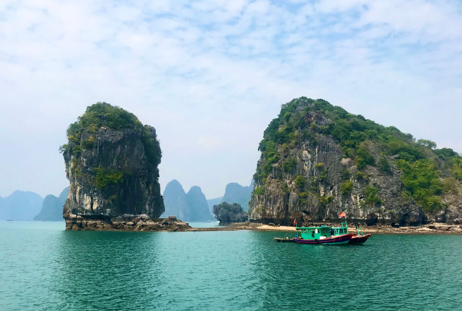
But neither of these grand sites carries the cachet of Ha Long Bay, the single leading tourist attraction in all of Vietnam. Designated as a UNESCO World Heritage Site in 1994, the bay teases tourists with more than 2,000 lofty islands, many of them no larger than the cruise ships that ride the tides here. Spread through the cerulean waters of the Gulf of Tonkin, the islets shelter scores of isolated floating villages and countless grottoes beloved by awestruck kayakers.

From my hotel room in Hanoi, where I had been laid up for two weeks with the flu (yes, that flu), I could only yearn to continue my travels with a trip to Ha Long. As soon as I was once again able expose myself to the world, I found enthusiastic and able assistance in the Old Quarter at Ethnic Travel. Its marvelous owners, Khanh and Mai Thú, both fluent in English, not only head up a team of guides; they also operate a traditional craft market and bookstore from their shop, and Khanh is more than happy to suggest reading material.

With my travel time curtailed by illness, they recommended that I focus on Cát Bà island, a far less congested destination than the usual gateway of Ha Long City. On Cát Bà, they told me, I wouldn’t contend with a waterfront lined with high-rise hotels nor a scramble for luxury cruises. Cát Bà, they said, was much more laid back, and, bonus!, it was much closer to pristine Lan Ha Bay, a body of water they consider the best of the entire Gulf of Tonkin.
Getting there
My three-day, two-night visit to Cát Bà Island began with a two-hour early-morning charter-bus ride from Hanoi. The modern highway skirted the industrial city of Haiphong, a not-quite-suburb of Hanoi with a million people, standing on its own at the mouth of the broad Red River. A transit of a new suspension bridge and a short car ferry took us to Cát Bà, largest of a string of islands surrounding Ha Long Bay.
The island’s only true town is eponymously named Cát Bà. Wrapped around a horseshoe-shaped harbor near the south end of the island, it features a number of modest low-rise hotels and a seemingly equal number of floating seafood restaurants.
I was dropped at LePont Cát Bà Bungalow. Apart from an awesome view over the busy anchorage, it was little more than a glorified hostel: Its restaurant didn’t serve dinners, its bar didn’t have beer. But it served its purpose for an inexpensive two-night stay.

A six-hour tour
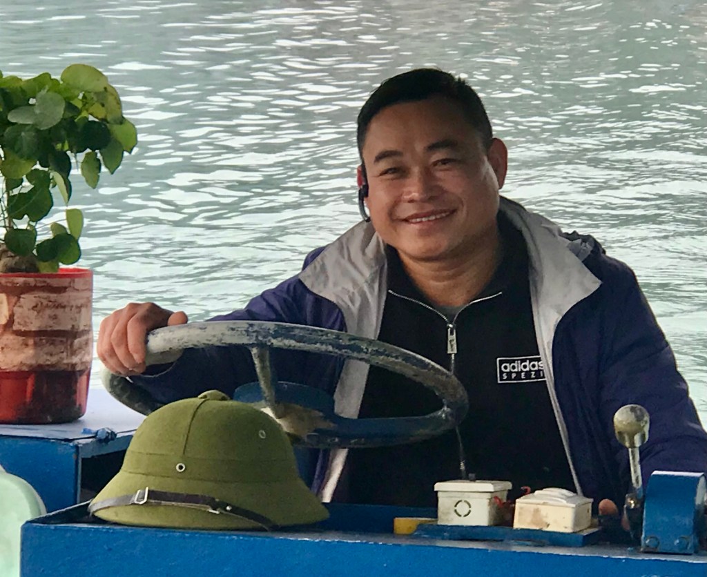
I spent the next full day on the water. Captain Phạm Duc Canh met me at the tiny Ben Beo harbor, on the back side of the town amidst karst hills shrouded in thick foliage and morning mist. For the next six hours, I had a private tour in his utilitarian boat, built to accommodate about a dozen but today hosting only myself.
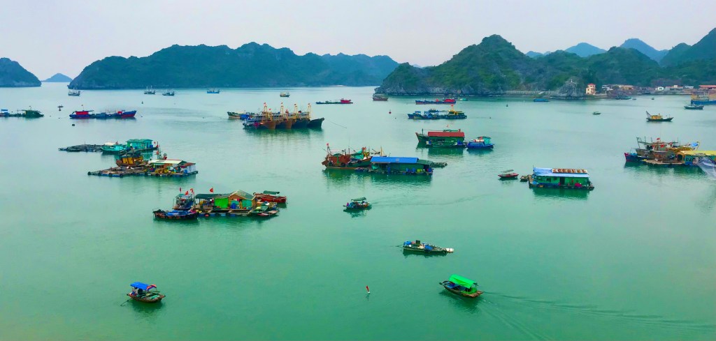
At least a couple of hundred houseboats — primitive shacks on hand-built rafts — crowded both sides of the waterway as we eased away from Ben Beo. I felt that I was intruding on the residents’ home lives, as I looked to and through one-room abodes where couples cooked, cleaned and prepared for their days ahead.

Always, it seemed, there were dogs on these buoyant perches, challenging all who could hear their defiant barks to stay far away. In a neighborhood with no gates, locks, alarm systems or any other form of security, the canines are indeed their owners’ best friends.

Fjord-like environs
But neither woofs nor words could begin to describe the grandeur of the natural environment here. As we sputtered along at a speed of around 20 knots, I was reminded of passage through a Norwegian fjord. A very few buoys and posted signs directed us through the channel; but so steep were the surrounding mounts, I doubt if there was any danger of reefs or sandbars.

Then suddenly the close geological environs vanished. We turned one rocky corner and found ourselves staring at a stunning panorama of miniature alps, each capped with tussocks of gnarled native vegetation with roots strong enough to pierce limestone rock. Some of the larger islands were named for animals they were thought to resemble: Monkey Island, Turtle Island. Here and there, remote and rustic resorts nestle against rocks and palms facing small sandy beaches.
I suspect the owner of a marine petrol station must feel a little like a lighthouse keeper in his isolation. He provides an essential service, but unless he has an associate to give him backup relief, it’s got to be kind of like Hotel California: He can check out any time he likes, but he can never leave. At least he has a dog, too.

Time for lunch
Captain Canh steered us to a lunch stop at a “homestay” on another floating outpost. We were served fish from the property’s own farmed enclosures, after which we were invited to share a peace pipe of robust tobacco from a homemade bong: I suspect it was not pure tobacco. On a muddy beach nearby, a simple shellfish farm boosted the culinary bounty. This small oasis also catered a handful of overnight guests, with post-pandemic tourism on the upswing, so a small fleet of kayaks and paddle boards were stowed at the ready.

The captain and I spent our afternoon hours further exploring the broad bay. Small boats skittled along the shoreline, their pilots slapping the surf with long poles to chum fish by stirring up nutrients, or scavenging rocky outcrops for tiny shellfish known as óc, much loved by diners at seafood restaurants throughout Vietnam.

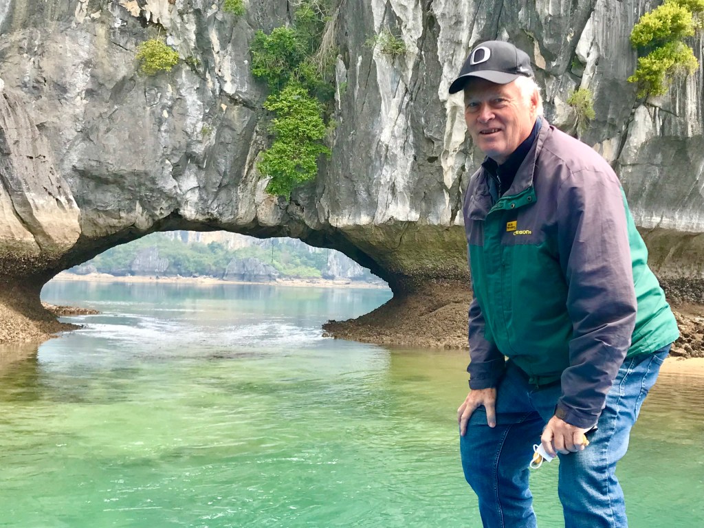
I had snapped a couple of hundred photos by the time Canh suggested a short detour to a maritime zone of natural bridges and grottoes. It was enchanting. And the captain himself took perhaps my favorite photograph from the day’s excursion, a shot of me (in University of Oregon garb: Go Ducks!) semi-crouched beside one arch as the tide rushes through. Magical. You can see that photo at the top of this story.
A national park
With a few free hours the next day, before I caught the bus back to Hanoi and a return flight to Ho Chi Minh City, I borrowed a motorbike to explore a small part of the interior of this island — the jungle precinct known as Cát Bà National Park.
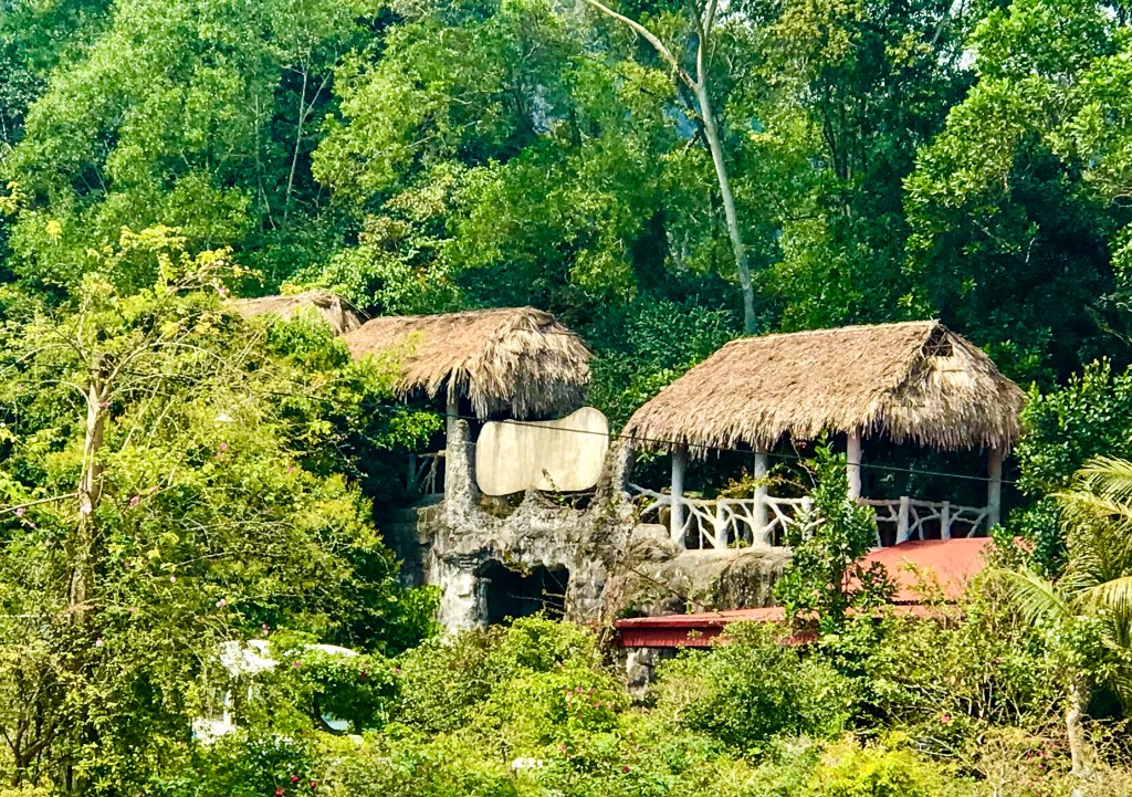
It’s not exactly what a North American expects to see in a national park, but the grounds were readily accessible via the main cross-island highway. Beyond a ticket gate, a simple headquarters building and an open-air pavilion featured interpretive signs describing the park’s flora and fauna. The animals include the rare golden-headed langur, a severely endanged species that I did not have the fortune of seeing.
A lightly tarred one-lane road, lined with derelict wartime barracks and other structures, heads directly east for several kilometers from the entrance area. A small drive accesses a rustic backpackers’ resort, with a large swimming pond, in the middle of the forest. Trees are simply labeled with Vietnamese and Latin names, a generous gesture, perhaps, although it did nothing for this English speaker. There are several natural caves in the area, including the 17-room Hospital Cave, a hospital and safe house during the American War.
Had I continued on this route, I would eventually have reached a trail head to a mountain summit. But 18 kilometers (11 miles) was a longer hike than I was prepared for on this day.


Aloha John, You hit it out of the park with this installment of your travels—in my opinion one of the best you have written. The descriptions are so enticing. Now I want to go there. How sweet you make it sound. I am glad you’re healthy and enjoying your time away from the West. I live a quiet life in Kaaawa, Oahu, with husband and dog. The current news is, the vehicle access around Kahana Bay is limited since the water main put in in 1929 burst with enough pressure to cause a piece of the bridge to collapse, and that created a sinkhole during high tide. Cordially, Rebekah
Sent from my iPhone http://www.rebekahstudio.blog
>
LikeLike
Hi John,
I’m glad you’ve recovered from the virus. This latest post is one of my favorites, it seemed like an adventure story.
Have fun,
Joe
LikeLike
This brings back memories of our time there ..such an amazing site we visited..great images.
LikeLike